Skip to Content
Skip to Nav
Skip to Search
Department of Transport homepage Department of Transport homepage Your Move homepage Your Move homepage
  • Schools
  • Organisations
  • Latest News
  • Resources
  • Journey Planner
Login
  1. Home
  2. / Resources
  3. / Walk, Wheel, Ride local area maps

Menu

Home

Stories

Latest News

Resources

Journey Planner

Register

Login

Walk, Wheel, Ride local area maps

Walking, wheeling and riding are great ways to get active in your local area.

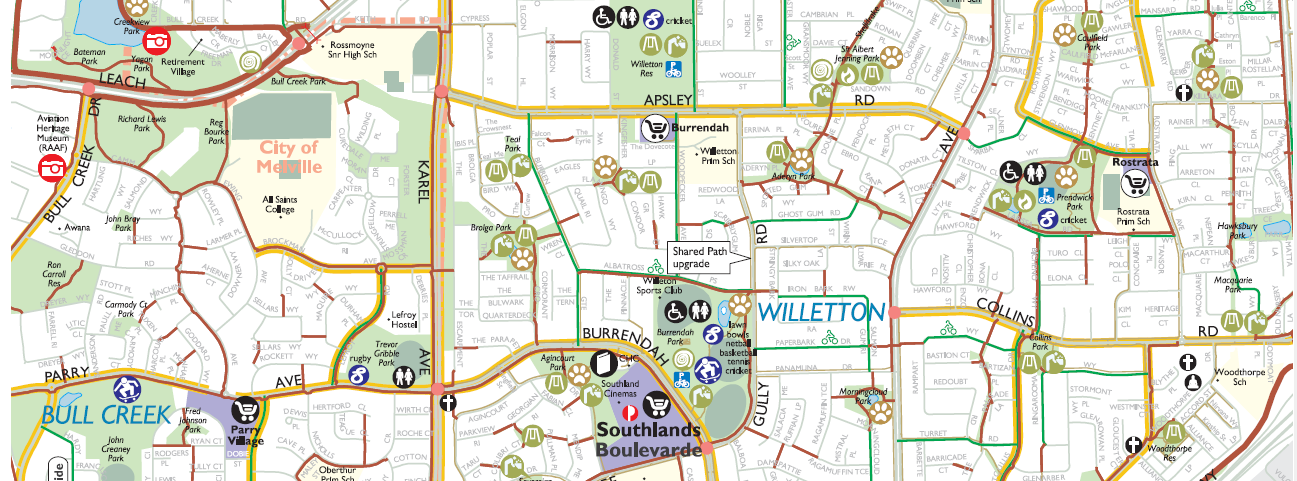
These local area maps identify walking and bike friendly routes, quiet streets, on-road bike lanes and shared paths, making it easier for you to choose more active ways to get around for your everyday journeys.

Think about the local trips that you make without a car such as going to the shops, work, dropping the kids at school or visiting friends. 

‘Walk, Wheel, Ride’ local area maps are produced in partnership with local government to help you explore your community.

The maps explained

Each ‘Walk, Wheel, Ride' map is dual sided. One side of the map helps you plan a trip by foot, bike, or other micromobility device, showing bike routes, shared paths, bike lanes, walking trails, bike shops, bike repair stations and bike parking. The other side helps you plan to catch public transport as part of your trip, showing bus routes, train stations, bus stops and wheelchair accessible services. 

Both sides show local facilities such as supermarkets, dog exercise areas, public toilets, skate parks, playgrounds and post boxes.

Viewing the maps

Free mobile friendly versions of these maps can be downloaded to your smart phone or device using a GPS based offline map viewer like the Avenza app, available for iOS and Android devices. The beauty of using an app like this is it allows you to view the maps on a mobile device and locate your position using GPS. It does not require internet or mobile phone network connections.

Look for the QR code and link in the information section for each map. Free printed copies are also available from some of the local government offices. Check the maps for contact details.

Please note that bus and bike routes may have changed since initial publication of the maps.

Walk, wheel, ride maps for your local area:

City of Albany map

About this map:

This local area map identifies walking and bike friendly routes, quiet streets, on-road bicycle lanes and shared paths to help you move around the City of Albany. Download the pdf and view it on your desktop or laptop to help you plan your journey by foot, bike or public transport around your local neighbourhood.


Mobile friendly versions of this map can be downloaded to your smart phone or device using a GPS based offline map viewer like the Avenza app, available for iOS and Android devices. Scan the QR code below or click this link to download this map directly to your mobile device.


Download
City of Armadale map

About this map:

This local area map identifies walking and bike friendly routes, quiet streets, on-road bicycle lanes and shared paths to help you move around the City of Armadale. Download the pdf and view it on your desktop or laptop to help you plan your journey by foot, bike or public transport around your local neighbourhood.


Mobile friendly versions of this map can be downloaded to your smart phone or device using a GPS based offline map viewer like the Avenza app, available for iOS and Android devices. Scan the QR code below or click this link to download this map directly to your mobile device.


Download
City of Belmont map

About this map:

This local area map identifies walking and bike friendly routes, quiet streets, on-road bicycle lanes and shared paths to help you move around the City of Belmont. Download the pdf and view it on your desktop or laptop to help you plan your journey by foot, bike or public transport around your local neighbourhood.


Mobile friendly versions of this map can be downloaded to your smart phone or device using a GPS based offline map viewer like the Avenza app, available for iOS and Android devices. Scan the QR code below or click this link to download this map directly to your mobile device.


Download
Town of Bassendean map

About this map:

This local area map identifies walking and bike friendly routes, quiet streets, on-road bicycle lanes and shared paths to help you move around the Town of Bassendean. Download the pdf and view it on your desktop or laptop to help you plan your journey by foot, bike or public transport around your local neighbourhood.


Download
City of Cambridge map

About this map:

This local area map identifies walking and bike friendly routes, quiet streets, on-road bicycle lanes and shared paths to help you move around the City of Cambridge. Download the pdf and view it on your desktop or laptop to help you plan your journey by foot, bike or public transport around your local neighbourhood.


Mobile friendly versions of this map can be downloaded to your smart phone or device using a GPS based offline map viewer like the Avenza app, available for iOS and Android devices. Scan the QR code below or click this link to download this map directly to your mobile device.


Download
City of Canning map

About this map:

This local area map identifies walking and bike friendly routes, quiet streets, on-road bicycle lanes and shared paths to help you move around the City of Canning. Download the pdf and view it on your desktop or laptop to help you plan your journey by foot, bike or public transport around your local neighbourhood.


Mobile friendly versions of this map can be downloaded to your smart phone or device using a GPS based offline map viewer like the Avenza app, available for iOS and Android devices. Scan the QR code below or click this link to download this map directly to your mobile device.


Download
City of Cockburn East map

About this map:

This local area map identifies walking and bike friendly routes, quiet streets, on-road bicycle lanes and shared paths to help you move around the City of Cockburn. Download the pdf and view it on your desktop or laptop to help you plan your journey by foot, bike or public transport around your local neighbourhood.


Mobile friendly versions of this map can be downloaded to your smart phone or device using a GPS based offline map viewer like the Avenza app, available for iOS and Android devices. Scan the QR code below or click this link to download this map directly to your mobile device.


Download
City of Cockburn West map

About this map:

This local area map identifies walking and bike friendly routes, quiet streets, on-road bicycle lanes and shared paths to help you move around the City of Cockburn. Download the pdf and view it on your desktop or laptop to help you plan your journey by foot, bike or public transport around your local neighbourhood.


Mobile friendly versions of this map can be downloaded to your smart phone or device using a GPS based offline map viewer like the Avenza app, available for iOS and Android devices. Scan the QR code below or click this link to download this map directly to your mobile device.


Download
City of Fremantle map

About this map:

This local area map identifies walking and bike friendly routes, quiet streets, on-road bicycle lanes and shared paths to help you move around the City of Fremantle. Download the pdf and view it on your desktop or laptop to help you plan your journey by foot, bike or public transport around your local neighbourhood.


Mobile friendly versions of this map can be downloaded to your smart phone or device using a GPS based offline map viewer like the Avenza app, available for iOS and Android devices. Scan the QR code below or click this link to download this map directly to your mobile device.


Download
City of Geraldton map

About this map:

This local area map identifies walking and bike friendly routes, quiet streets, on-road bicycle lanes and shared paths to help you move around the City of Geraldton. Download the pdf and view it on your desktop or laptop to help you plan your journey by foot, bike or public transport around your local neighbourhood.


Download
City of Gosnells map

About this map:

This local area map identifies walking and bike friendly routes, quiet streets, on-road bicycle lanes and shared paths to help you move around the City of Gosnells. Download the pdf and view it on your desktop or laptop to help you plan your journey by foot, bike or public transport around your local neighbourhood.


Mobile friendly versions of this map can be downloaded to your smart phone or device using a GPS based offline map viewer like the Avenza app, available for iOS and Android devices. Scan the QR code below or click this link to download this map directly to your mobile device.


Download
City of Joondalup North map

About this map:

This local area map identifies walking and bike friendly routes, quiet streets, on-road bicycle lanes and shared paths to help you move around the City of Joondalup. Download the pdf and view it on your desktop or laptop to help you plan your journey by foot, bike or public transport around your local neighbourhood.


Mobile friendly versions of this map can be downloaded to your smart phone or device using a GPS based offline map viewer like the Avenza app, available for iOS and Android devices. Scan the QR code below or click this link to download this map directly to your mobile device.


Download
City of Joondalup South map

About this map:

This local area map identifies walking and bike friendly routes, quiet streets, on-road bicycle lanes and shared paths to help you move around the City of Joondalup. Download the pdf and view it on your desktop or laptop to help you plan your journey by foot, bike or public transport around your local neighbourhood.


Mobile friendly versions of this map can be downloaded to your smart phone or device using a GPS based offline map viewer like the Avenza app, available for iOS and Android devices. Scan the QR code below or click this link to download this map directly to your mobile device.


Download
City of Melville map

About this map:

This local area map identifies walking and bike friendly routes, quiet streets, on-road bicycle lanes and shared paths to help you move around the City of Melville. Download the pdf and view it on your desktop or laptop to help you plan your journey by foot, bike or public transport around your local neighbourhood.


Mobile friendly versions of this map can be downloaded to your smart phone or device using a GPS based offline map viewer like the Avenza app, available for iOS and Android devices. Scan the QR code below or click this link to download this map directly to your mobile device.


Download
City of Nedlands (including UWA)

About this map:

This local area map identifies walking and bike friendly routes, quiet streets, on-road bicycle lanes and shared paths to help you move around the City of Nedlands and UWA. Download the pdf and view it on your desktop or laptop to help you plan your journey by foot, bike or public transport around your local neighbourhood.


Download
City of Perth map

About this map:

This local area map identifies walking and bike friendly routes, quiet streets, on-road bicycle lanes and shared paths to help you move around the City of Perth. Download the pdf and view it on your desktop or laptop to help you plan your journey by foot, bike or public transport around your local neighbourhood.


Download
City of Rockingham North map

About this map:

This local area map identifies walking and bike friendly routes, quiet streets, on-road bicycle lanes and shared paths to help you move around the City of Rockingham. Download the pdf and view it on your desktop or laptop to help you plan your journey by foot, bike or public transport around your local neighbourhood.


Download
City of Rockingham South map

About this map:

This local area map identifies walking and bike friendly routes, quiet streets, on-road bicycle lanes and shared paths to help you move around the City of Rockingham. Download the pdf and view it on your desktop or laptop to help you plan your journey by foot, bike or public transport around your local neighbourhood.


Download
City of South Perth map

About this map:

This local area map identifies walking and bike friendly routes, quiet streets, on-road bicycle lanes and shared paths to help you move around the City of South Perth. Download the pdf and view it on your desktop or laptop to help you plan your journey by foot, bike or public transport around your local neighbourhood.


Download
City of Stirling East map

About this map:

This local area map identifies walking and bike friendly routes, quiet streets, on-road bicycle lanes and shared paths to help you move around the City of Stirling. Download the pdf and view it on your desktop or laptop to help you plan your journey by foot, bike or public transport around your local neighbourhood.


Mobile friendly versions of this map can be downloaded to your smart phone or device using a GPS based offline map viewer like the Avenza app, available for iOS and Android devices. Scan the QR code below or click this link to download this map directly to your mobile device.


Download
City of Stirling West map

About this map:

This local area map identifies walking and bike friendly routes, quiet streets, on-road bicycle lanes and shared paths to help you move around the City of Stirling. Download the pdf and view it on your desktop or laptop to help you plan your journey by foot, bike or public transport around your local neighbourhood.


Mobile friendly versions of this map can be downloaded to your smart phone or device using a GPS based offline map viewer like the Avenza app, available for iOS and Android devices. Scan the QR code below or click this link to download this map directly to your mobile device.


Download
City of Subiaco map

About this map:

This local area map identifies walking and bike friendly routes, quiet streets, on-road bicycle lanes and shared paths to help you move around the City of Subiaco. Download the pdf and view it on your desktop or laptop to help you plan your journey by foot, bike or public transport around your local neighbourhood.


Mobile friendly versions of this map can be downloaded to your smart phone or device using a GPS based offline map viewer like the Avenza app, available for iOS and Android devices. Scan the QR code below or click this link to download this map directly to your mobile device.


Download
City of Swan North map

About this map:

This local area map identifies walking and bike friendly routes, quiet streets, on-road bicycle lanes and shared paths to help you move around the City of Swan. Download the pdf and view it on your desktop or laptop to help you plan your journey by foot, bike or public transport around your local neighbourhood.


Mobile friendly versions of this map can be downloaded to your smart phone or device using a GPS based offline map viewer like the Avenza app, available for iOS and Android devices. Scan the QR code below or click this link to download this map directly to your mobile device.


Download
City of Swan South map

About this map:

This local area map identifies walking and bike friendly routes, quiet streets, on-road bicycle lanes and shared paths to help you move around the City of Swan. Download the pdf and view it on your desktop or laptop to help you plan your journey by foot, bike or public transport around your local neighbourhood.


Mobile friendly versions of this map can be downloaded to your smart phone or device using a GPS based offline map viewer like the Avenza app, available for iOS and Android devices. Scan the QR code below or click this link to download this map directly to your mobile device.


Download
Town of Victoria Park map

About this map:

This local area map identifies walking and bike friendly routes, quiet streets, on-road bicycle lanes and shared paths to help you move around the Town of Victoria Park. Download the pdf and view it on your desktop or laptop to help you plan your journey by foot, bike or public transport around your local neighbourhood.


Mobile friendly versions of this map can be downloaded to your smart phone or device using a GPS based offline map viewer like the Avenza app, available for iOS and Android devices. Scan the QR code below or click this link to download this map directly to your mobile device.


Download
City of Vincent map

About this map:

This local area map identifies walking and bike friendly routes, quiet streets, on-road bicycle lanes and shared paths to help you move around the City of Vincent. Download the pdf and view it on your desktop or laptop to help you plan your journey by foot, bike or public transport around your local neighbourhood.


Mobile friendly versions of this map can be downloaded to your smart phone or device using a GPS based offline map viewer like the Avenza app, available for iOS and Android devices. Scan the QR code below or click this link to download this map directly to your mobile device.


Download
City of Wanneroo Central map

About this map:

This local area map identifies walking and bike friendly routes, quiet streets, on-road bicycle lanes and shared paths to help you move around the City of Wanneroo. Download the pdf and view it on your desktop or laptop to help you plan your journey by foot, bike or public transport around your local neighbourhood.


Mobile friendly versions of this map can be downloaded to your smart phone or device using a GPS based offline map viewer like the Avenza app, available for iOS and Android devices. Scan the QR code below or click this link to download this map directly to your mobile device.


Download
City of Wanneroo North map

About this map:

This local area map identifies walking and bike friendly routes, quiet streets, on-road bicycle lanes and shared paths to help you move around the City of Wanneroo. Download the pdf and view it on your desktop or laptop to help you plan your journey by foot, bike or public transport around your local neighbourhood.


Mobile friendly versions of this map can be downloaded to your smart phone or device using a GPS based offline map viewer like the Avenza app, available for iOS and Android devices. Scan the QR code below or click this link to download this map directly to your mobile device.


Download
City of Wanneroo South map

About this map:

This local area map identifies walking and bike friendly routes, quiet streets, on-road bicycle lanes and shared paths to help you move around the City of Wanneroo. Download the pdf and view it on your desktop or laptop to help you plan your journey by foot, bike or public transport around your local neighbourhood.


Mobile friendly versions of this map can be downloaded to your smart phone or device using a GPS based offline map viewer like the Avenza app, available for iOS and Android devices. Scan the QR code below or click this link to download this map directly to your mobile device.


Your Move Journey Planner

Try our multi-mode journey planner (powered by SkedGo) to help you find more ways to get from A to B with any combination of transport modes, in real-time! Modes include walking, bike riding, train, bus, taxi, ferry and car. 


Download
Plan a journey now
wa.gov.au Copyright © 2024 Your Move
Terms of Use Privacy Accessibility Contact Us About Your Move FAQs

Cookie Consent

We use cookies to ensure you get the best experience. Please choose the cookie level that's appropriate for you. We recommend allowing all cookies to ensure you get the most out of our website. Cookie Policy.
I Agree
Dismiss